|
Copyright © Ray Crowther 2025 |
||||||||
|
Internet Table-Top Rally Championship 2003 |
||||||||
|
Route
Card 1 TC1A @ Parkend in Km Square 0979 via 894. Link to TC2A. Proceed via spot heights 48, 56, 43, 185, 51, 47, 51, 134, 116, 163 whose sum was 894 - NOT 48, 43, 185, 51, 47, 134, 116, 163, 69, 38 which was about 2Km longer. It wasn't my intention to be so sneaky, but it has sorted the men from the minnows (I'm one of the minnows). SH48, Y>O(1), SH56, SH43, Y>W(1), Not Hartwood, GL07(1), GL07(2), SH185, W>Y, YYY(1), Y>O(2), SH51, SH47, SH51, OOO, E(1174), O>Y, S(1073), YYY(2), YYY(3), SH134, YYY(4), SH116, Craigie, YYY(5), SH163(SH10), YYY(6), GL07(3), YGG(1), GL07(4).
Route Check Answers Route
Card 2 TC2A @ MS in Km Square 1171, depart SE
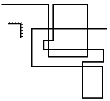
Link to TC3A. Starting in the top left hand corner, follow the path of the lines where the length of each line (using the scale provided) represented the value of a spot height to be visited. The spot heights were 32, 36, 27, 36, 24, 25, 7, 7, 41, 9, 15, 25, 14, 22, 48, 26, 51. SH32, ETL(1), SH36, T(1), RU(1), SH27, WWW(1), WWW(2), WWW(3), SH36, W(0669), Y>W(1), SH24, SH25, WWW(4), WWW(5), GC(1-5), SH7, GC(6-12), T(2), GC(13-19), SH7, GC(20-30), Y>W(2), WWW(6), GC(31-37), T(3), GC(38-44), E(1666), ETL(2), SH41, ETL(3), RU(2), SH9, RU(3), SH15, SH25, RU(4), SH14, site, RU(5), SH22, ETL(4), SH48, ETL(5), Y>W(3), ETL(6), SH26, WWW(7), WWW(8), WWW(9), WWW(10), WWW(11), WWW(12), WWW(13), WWW(14), Not MR14106872, SH51. Route Check Answers Route
Card 3 TC3A @ 127 710NE Here are the results of today's tennis match between Ed Easting and Norman Northing. Ed served first. Whoever won the point gave the grid line, Easting or Northing, to cross. 15-0, 30-0, 40-0, 1-0. decoded to EEEE E, Y>O(1), SH74, E, SH73, E,
E/, N, Y>O(2), E, GN7,
SH48, N, N, E, Ch(1), N/, SH34, E, Y>O(3),
E, SH35, N, Y>O(4), E, SH36, E/, N, E, ETL(1),
G>O, E, Howes, ETL(2), E, N, E/, W>Y(1),
ETL(3), N, SH23, N, Y>O(5),
SH9, E, An absolute swine to settle on a route and mark. Many chose the longer route to the south of Annan rather the shorter route to the north. RC1: Immeasurable difference between 2165 and 2365, Route
Card 4 TC4A @ Bridge in Km Square 2567, depart E On the basis that GL60 is coded as 60, GL40 is coded as 60, GL72 is coded as 18, GL10 is coded as 0, GL24 is coded as 7, GL14 is coded as 9 etc., and it only works for GL numbers above 9, go via the following: 7, 48, 2, 35, 8, 8, 35, 2, 7, 35, 7, 22, 09, 09, 2, 8, 22, 4, 0, 35, 0, 4, 4, 48, 62, 4, 76, 8, 2, 7, 90, 2, 90, 7, 76, 2, 76, 8, 76, 62, 4, 62, 4, 76, 4 Crossing grid line numbers. Take the square of the grid number and discard the first and last digits to get the code e.g. 26*26 = 676 - coded as 7; 67*67 = 4489 - coded as 48 etc. so: 21=4(4)1, 22=4(8)4, 23=5(2)9, 24=5(7)6, 25=6(2)5, 26=6(7)6, 27=7(2)9, 28=7(8)4, 29=8(4)1, 30=9(0)0, 64=4(09)6, 65=4(22)5, 66=4(35)6, 67=4(48)9, 68=4(62)4, 69=4(76)1, 70=4(90)0. Therefore go via GLs: 26, 67, 27, 66, 28, 28, 66, 27, 26, 66, 26, 65, 64, 64, 27, 28, 65, 29, 30, 66, 30, 29, 29, 67, 68, 29, 69, 28, 27, 26, 70, 25, 70, 24, 69, 23, 69, 22, 69, 68, 21, 68, 21, 69, 21 ETL(1), 26, 67, 27, (NOT longer white), RU(1), ETL(2), 66, 28, Y>W(1), 28, 66, 27, GC?, OOW(1), GC(1-3), 26, GC(4), OOW(2), 66, RU?, 26, RU?, 65, RU?, RU?, RU?, RU?, 64, S(2663), 64, 27, 28, 65, SH8, Y>W(2), 29, SH8, 30, E(3065), 66, 30, ETL(3), GC(5-8), 29, 29, 67, RU(2), SH12, 68, 29, SH19(SH4), ETL(4), 69(1), 28, 27, SH47, SH38, 26, ETL(5), OOW(3), ETL(6), 70, 25, SH73, 70, SH64, 24, SH69, ETL(7), Y>W(3), 69(2), "Tower", 23, 69(3), ETL(8), 22, ETL(9), 69(4), SH68, 68, 21, RU(3)?, 68, ETL(10), Y>W(4), 21, RU(4)?, 69(5), 69(6?), 69(7?), ETL(11), ETL(12), 21. RC6: 2 normal unders and 2 dismantled unders? and 6 narrow
gauge unders?
Route Check Answers Route
Card 5 TC5A @ Bridge in 2069, depart NW 24UC, UQ, 2, RO, RQ, LTUB, 24UN, ET, JOUER, 24UWT, EE, 24, 24UV, 24, 24UN, GEUWO, 24UWT, TT, RE, SJRW, 3AUUTW, RW, RR, 14, 12, YT, OE, 24UV, UI. Link to TC6A. Study the QWERTY keyboard layout and number the letters in order from 1 to 26: Q(1) W(2) E(3) R(4) T(5) Y(6) U(7) I(8) O(9) P(10) A(11) S(12) D(13) F(14) G(15) H(16) J(17) K(18) L(19) Z(20) X(21) C(22) V(23) B(24) N(25) M(26). Use the combinations to decode the clue as a route defined by the following: B722, 71, W, 49, 41, 195724, B725, 35, 179734, B725, 33, B, B723, B, B725, 153729, B725, 55, 43, 121742, E117752, 42, 44, F, S, 65, 93, B723, 78. B722, SH71, Y>W(1), WWW(1), "W", WWW(2), SH49, YYYY(1), SH41, Y>W(2), MR195724, WWW(3), Meinbank, BrO(1), Y>W(3), B725, SH35, O>W(1), MR179734, "Bush", B725, "B", B723, BrO(2), O>W(2), "B", B725, O>W(3), WWW(4), WWW(5), WWW(6), WWW(7), "Hoddom" Castle, 153729, B725, SH55, SH43, O>W(4), WWW(8), 121742, E117752, BrO(3), SH42, YYYY(2), W(1077), SH44, Y>W(4), "F", Y>W(5), "S", SH65, YYYY(3), N(1379), Y>W(6), SH93, B723, SH78. RC9: The "H" is definitely a capital. Compare it with the lowercase "h" of church in the same Gothic font elsewhere on the map.
Route Check Answers Route
Card 6 TC6A @ X roads in 1377 3649 4369 5267 5484 4788 5973 6373 9858 9449 0644 1953 1569 3755 2044 2041 Link to TC7A. Pretty straightforward? Just the leading digits of the Eastings and Northings were removed, leaving four-digit map references. The full references were: 136749 143769 152767 154784 147788 159773 163773 198758 194749 206744 219753 215769 237755 220744 220741 SH107, SH78, 136749, Y>W(1), Y>W(2), 143769, Ch?, SH47, SH57, O>Y(1), Y>W(3), 152767, 154784, 147788, N(1478), B7076, O>Y(2), 159733, Y>W(4), RO(1), B7076, O>W, 163733, Y>W(5), SH153(SH5), 198758, B725, RO(2), GC(1), O>Y(3), Y>W(6), 194749, W>Y, Ch(1), B7076, GC(2-7), O>W, 206744, SH64, RU(1), "ORT", 219753, Ch(2), O>Y(4), SH101, T(1), Y>W(7), 215769, B725, SH92, SH108, E(2477), SH119, O>Y(5), 237755, Y>W(8), RO(3), 220744, B7076, GC(8), 220741. RC4: Debatable church in 1477.
Route Check Answers Route
Card 7 TC7A @ Bridge in 2272, depart SE Not all diagrams are shown.
These kilometre squares were notched at the every entry and exit point. Then, simply plot the shortest route. The squares intended were: 2472, 2671, 2574, 2776, 3073. However, accepting a graphical margin of error, the second diagram could have also referred to square 2972! Given that not every square was shown, I had to also accept this alternative and possibly shorter route. The two alternatives are shown below as [ ] and { }. BrO?, SH98, TR, MR, Y>W(1), GL24, GL24, W>Y, BrU(1), GL24, GL24, BrO(1), GL73, B7076, GL73, BrO?, GL24, BrU(2), GL72, GL25, [ O>Y, BrO(2), "ROM", Y>W(2), GL26, WWW(1), WWW(2), ] {O>W, BrO(1), } WWW(3/1), GL27, Wysebyhill, GL25, W>Y, GL73, SH79(SH2), SH99, GL25, GL25, BrO(3), Y>W(3/2), GL25, BrO(4), GL75(1), WWW(4/2), GL75(2), WWW(5/3), GL75(3), WWW(6/4), WWW(7/5), WWW(8/6), ETL(1), W>Y, BrO(5), B722, BrO(6), Hotts, N(2678), O>Y, BrO(7), SH135, SH166, SH127, SH102, E(3175), BrO(8), GL75(4), SH109, SH108, ETL(2), ETL?, ETL?, GL75(5), SH119, ETL(3), SH156, ETL(4), SH124, GL75(6), SH86, SH88, SH98, SH89, B6357, SH74, O>W. RC7: 8 + include bridge at start? + include hidden bridge at 240730?
Route Check Answers Route
Card 8 TC8A @ Raeburnhead, depart WSW In order tulips with crossroads omitted. Here they are with the crossroads and answers included.
RC9: Debatable RO LC in 2870.
Route Check Answers Route
Card 9 TC9A @ SH141 in 3278 Take the shortest route via the following out-of-order points: January 8, January 10, February 9, March 5, March 11, April 11, May 5, May 13, May 15, June 3, June 7, July 8, August 14, September 6, September 9, November 1. Write the dates as digits DM, DDM or DMM, treat them as spot heights, then sort into the correct order: 111, 114, 101, 99, 55, 69, 92, 76, 36, 87, 81, 148, 135, 113, 155, 53. 111, 114, 101, 99, Not Hagg, W>Y(1), 55, Ch(1), 69, 92, OOO(1), 76, S(3873), ETL(1), 36, O>W(1), BrO(1), ETL(2), BrO(2), OOO(2), Ch(2), BrO(3), O>W(2), ETL(3), W>Y(2), 87, 81, ETL(4), ETL(5), 148, 135, BrO(4), 113, N(4179), 155, ^(1), OOO(3), ^(2), 53, BrO(5), ^(3), BrO?, O>W(3), W>Y(3). RC6: Debatable bridge symbol embedded in embankment in 4377.
Route Check Answers Route
Card 10 TC10A @ X roads in 4476 __riB|__|__|__|_||_|_._|||._|_|_._2||_|_.9|._S __||_||_|.|{|___|}_|.|o|noot_o|__{|_|}_|__ (Ignore any unknown route check information between the curly brackets) Passing through features that block the route. Mostly Eastings and Northings and colour keyed to help. Just to be awkward you were taken off the map a couple of times. The full decoded sequence was: _(GL76), _(GL75), riB, |(GL44), _(GL74), _(GL73), |(GL43), _(GL73), Not "Lambhill", _(GL74), |(GL42), _(T), _(GL74), |(GL41), BrO(1), _(GL73), |(GL41), |(GL42), _(GL72), |(GL43), _(T), .(SH125), _(GL71), |(GL43), |(GL42), |(GL42), .(SH69)SH2, _(GL71), |(GL42), _(GL72), |(GL41), _(GL72), .(SH52), _(Gate), Y>W(1), 2(GN2), |(GL40), WWW(1), WWW(2), |(GL40), _(Gate), |(GL40), _(GL71), .(SH35), 9(GN9), |(GL39), .(SH23)SH5, _(GL70), S(letter), Y>W(2), W(3869), WWW(3), {WWW(4), WWW(5), _(GL69), WWW(6), _(GL69),} or {WWW(4), WWW(5), _(GL69), WWW(6), _(GL69), WWW(7), WWW(8), WWW(9),} |(GL39), |(GL40), _(GL69), |(GL41), |(GL42), _(GL69), |(GL43), .(SH56), |(GL44), {|(GL45), _(GL70), _(GL70), _(GL69), |(GL45),} _(water), _(GL68), |(GL44), .(SH44), |(GL44), o(green circle), |(GL44), n(letter), o(green circle), ot(letters), _(GL67), o(green circle), |(GL44), _(GL67), _(GL67), {|(GL45), _(GL66), |(GL45),} |(GL44), _(GL66), _(GL66) RC1: Two equidistant routes through whites north of Longtown. NOT the longer yellow to the west.
Route Check Answers Route
Card 11 TC11A @ 4315 6554ESE Pass through the following type of junctions the specified number of times only.The first colour in a sequence is the approach; the second the departure. RYY(1), YYY(11), YWY(1), WWW(1), WYY(2), YGG(3), GGY(1), GYG(2), YYW(1), YYYY(1), GGYY(1), GWG(1), YYRR(1), YRR(2), RRY(4), RYR(1), RWR(1), WRR(1), RYGG(1). The correct sequence of junctions was: Ch(1), RYY, ETL(1), YYY, YYY, SH25, Not Dykes, YYY, ETL(2), ETL(3), YWY, ETL(4), ETL(5), ETL(6), ETL(7), WWW, GN4, WYY, YGG, S(4059), Ch(2), GGY, GYG, YYW, ETL(8), ETL(9), YGG, SH21(SH2), GYG, GN6, t, YYY, YYYY, YGG, GGYY, Ch(3), SH23, GWG, WYY, YYY, YYY, YYY, GC(1), GC(2), GC(3), ETL(10), SH26, GC(4), GC(5), GC(6), GC(7), GC(8), YYRR, GC(9), GC(10), GC(11), YYY, YRR, SH23, RRY, BrO(1), RRY, RRY, GN7, GN6, RRY, RYR, YYY, N(3968), YYY, Ch(4), YRR, RWR, WRR, Ch(5), RYGG, GC(12), ETL(11), GC(13), GC(14), GC(15), Ch(6), YYY, GC(16), GC(17).
Route Check Answers Route
Card 12 TC12A @ 379 665S Via the following junction departures: N, N, SS, SSW, S, SSW, SS, WSW, NW, WNW, SSW, N, S, S, W, NW, WSW, WSW, WNW, SW, N, S, SSW, SS, NN, NN, S, N, N, S, WSW, S, WNW, SW, NW. All the E's were missing. The unedited list was: N, E, N, SSE, SSW, E, S, SSW, SSE, WSW, NW, WNW, SSW, ENE, S, S, W, NW, WSW, WSW, WNW, SW, NE, SE, E, SSW, E, SSE, NNE, NNE, S, NE, ENE, S, WSW, S, WNW, SW, NW. and the route: N, Y>W(1), E, N, Y>W(2), SSE, W>G(1), {SSW, E, S, Y>W(3), SSW, WWW(1), SSE, W>G(2),} or {SSW, S, SSW, SSE, - sort of fits along green road} WSW, NW, WNW, Y>W(4), SSW, WWW(1/2), ENE, Y>W?, S, WWW(2/3), S, Y>W(5), W, NW, WSW, WSW, L?, RO(1)/RU(1)?, ETL(1), ETL(2), SH11, WNW, RD(1), SW, Y>W(6), NE, RD(2), SE, E, SSW, E, SSE, RD?, RD(3), Ch(1), NNE, NNE, B, ETL(3), ETL(4), RO(1/2), S, NE, ENE, Y>W(7), S, ETL(5), ETL(6), WSW, ETL(7), ETL(8), S, ETL(9), ETL(10), ETL(11), ETL(12), WNW, SW, NW, ETL(13). RC2/3: Over or Under at LC? RC6, RC7, RC10: Different answers if
second alternative route above used. |
||||||||
|
|


 RO(1)
RO(1) O>W(1)
 O>W(2)
RO(2) RO?(3)
O>W(2)
RO(2) RO?(3) RO(5)
RO(5) WWWW(1)
RO(6)
WWWW(1)
RO(6)