|
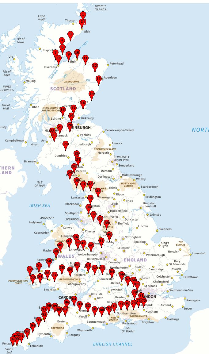
The outline route for HRCR Jogle 2021 is below: TC1 in John o'Groats
to TC101 in Land's End. There are 90 UK legs (based upon
Ordnance Survey maps) and 10 Other Legs (based upon other maps).
Each "5th" control is deliberately missing on the map. See below.
In
each of the UK legs the notional start and finish TCs have been
set. The current route from the start to the finish is usually
the shortest distance/quickest route via AutoP(i)lot. The finish
TC of a leg is close to or identical to the start of the next
leg.
The straight-line distance between each start and
finish averages about 20 miles.
The actual rally route for each leg is up to the setter with the
following guidelines:
1) The start and finish TCs should
be kept in roughly the same place. Don't move them more than a
kilometre from their current position. This preserves the Jogle
outline route.
2) The route from the start TC should
generally meander towards the finish TC. For example, if the
direction is north to south, don't head significantly further
north before going south. As a rough guide try to stick to a
corridor of no more than about 8 kilometres either side of a
straight-line route from the start TC to the finish TC.
3) Remember there are 100 legs on this event - a marathon not a
sprint - so ALL navigation must be STRAIGHTFORWARD. No cryptic
codes, no Google searching, no heavy maths, no unlock codes,
nothng complicated. Even the most adept and diligent competitors
will trip up somewhere in their plotting.
4) Choose your
STRAIGHTFORWARD route card navigation by utilising the map features
you can see in your corridor. If nothing looks inviting, just
define, say, 2/3/4 in-order PCs which have to be visited via the
shortest overall route. If the leg crosses mountains or follows
the coast, which limits the available roads, the section is
probably best used as a Real-Time leg with VERY STRAIGHTFORWARD
navigation.
5) No hints. The navigation should be doable directly from the
route card without solving cryptic clues or carrying out Google
searches.
6) For Plotting legs your route length should
be about 40 miles. For Real-Time legs keep them below 15 miles;
this may necessitate advancing the start TC and retracting the
finish TC to truncate the average distance. The aim is have
about 10% of the legs as Real-Time rallies.
7) The
default design parameters for each leg i.e. mapsets, zoom range
etc. should be left intact for event consistency unless special
reasons dictate otherwise.
Each "5th" leg (Legs 5,15,25
... 95) will use non-OS maps for variety. Any of the map sets in
the design software can be used for any country. By default
these legs have been set with a start and finish TC in France on
Open Street maps.
Your non-OS navigation should be of the
form: (e.g. for TC15 to TC16):
From TC15 (UK) teleport to
TC15 (France, or wherever) and complete the following route
card:
Route Card Instructions ...
From TC16 (France, or
wherever) teleport to TC16 (UK)
Each setter may set up to 5 legs. Given the STRAIGHTFORWARD
navigation, this should not be too time-consuming. Setters are obviously not permitted
to attempt their own leg and would usually receive a maximum score. However, since there will be
no dropping of worst scores on the Jogle Rally the following scheme has been
devised to not compromise a setter's score.
5 additional straightforward route cards will be created just for the setters. If
a setter has designed, say 3, legs, his/her substitute scores will
come from the results of their attempt at the first three additional route cards. Although this
is not a perfect "level playing field" it should provide an incentive for volunteer setters with
only a minor skew to the results.
|